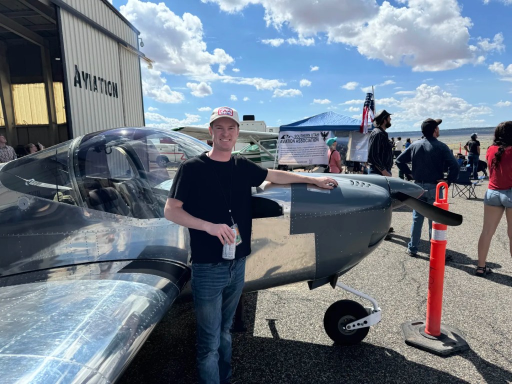
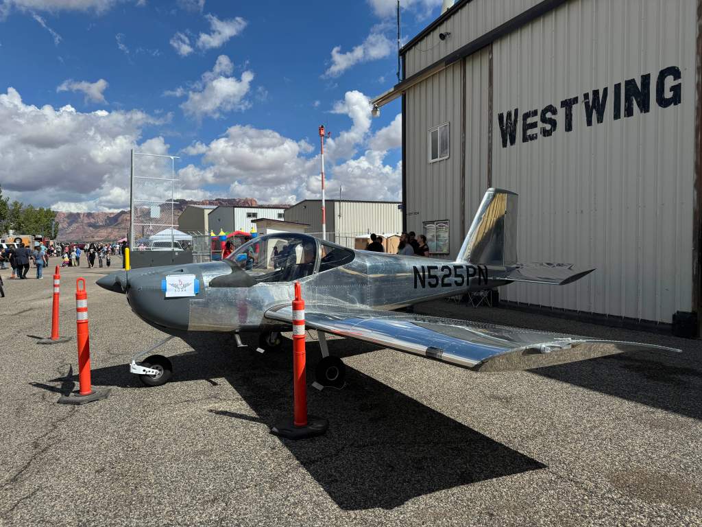
This trip was very interesting in that it was a last minute change to have the RV-12 on display in association with the Southern Utah Aviation Association and Experimental Aviation Association Chapter 936 of Saint George and Hurricane, UT at the Colorado City, AZ airshow. One of the EAA attendees had a last minute change and was unable to attend so he asked me if I was able to bring the RV-12 in his place for static display.
The RV-12 served as a wonderful display of Experimental Aviation and I had several wonderful conversations with people there wanting to know more about experimental aviation.
I strongly urge those in the Southern Utah region to join both the Southern Utah Aviation Association to stay up to date with local changes as well as advocate and communicate with the local area on some of the proposed ordinance changes in the area, as well as the Experimental Aviation Association to help support aviation and promote the industry to younger generations to foster the talent so desperately needed in all aspects of the aviation industry.
After the airshow had ended, I had already planned a trip down the Phoenix, AZ to visit a friend for the weekend. Flying down to Phoenix, AZ from the Saint George area is quite a bit different as it requires either flying over the Grand Canyon via a VFR corridor with special rules that have to be followed or to fly around the Grand Canyon by flying east over to Page, AZ and then heading south to Phoenix. This choice depends on the cloud ceilings and the performance of the aircraft for the day, if the cloud bases are below 11,000 ft. MSL or if the day is hot enough to prevent climbing up to 10,500 ft. MSL, then I would have to fly around the grand canyon and add about an hour of extra flight time to get to Phoenix. But the conditions of the day allowed me to fly the VFR corridor and save the time and fuel to get to Phoenix.
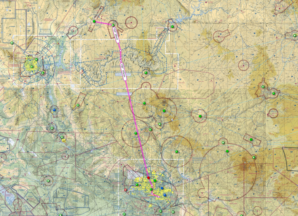
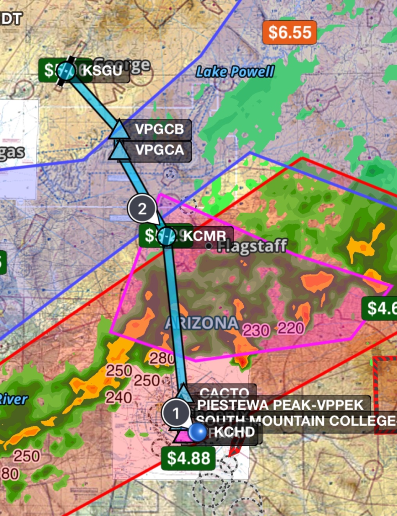
This is the route that was flown for the day. After Getting out of the Grand Canyon airspace I descended back down to 9,500 ft. MSL in compliance with VFR flight rules about flying on an an easterly heading (flying a heading between 360-179, you will fly on the odd thousands plus 500 ft., 180-359 on even thousands plus 500 ft.) When flying through the Grand Canyon, there are extra steps when flying South or North.
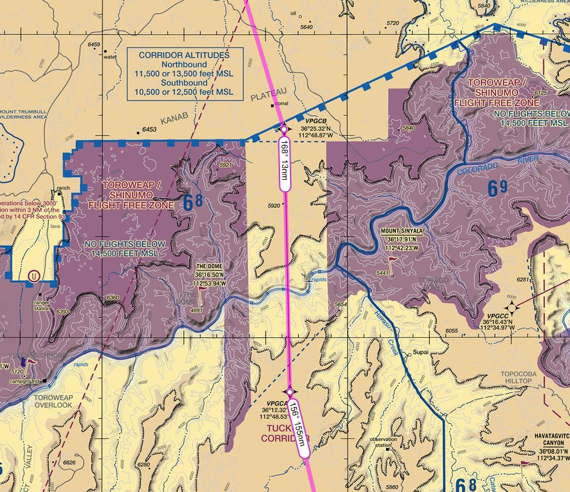
We can see here flying through the Tuckup Corridor there’s specific altitudes you must adhere to depending on if you are heading North or South and you must enter and exit at those specific waypoints before continuing on your way.
Throughout the flight I had picked up VFR flight following from Los Angeles Center just before entering the grand canyon airspace and they provided additional traffic and weather information advisories and handed me off to Albuquerque control for a short bit before then handing me off again to Phoenix Approach Control as I got closer to Phoenix.
One note that most people are not familiar with as well as some pilots is that radar weather information can be outdated in a matter of minutes and you will receive advisories from ATC that may not be applicable to what’s happening right in front of you. This is because ATC cannot physically see what you are seeing and can only really see what the radar sees. In this case I had received an advisory that there was “Severe to Extreme precipitation 10’o clock 5 miles ahead and Moderate to Severe precipitation 12 o’ clock 10 miles ahead extending for 5 miles”. The reality was that the storms they were describing had already moved east a significant amount and when looking at the weather data I was receiving it was clear that the weather radar data was outdated by a few minutes and storms in the desert region can quickly develop and dissipate in a matter of minutes.
Here you can see the difference of what the weather is directly in front of me vs what is being shown on the panel. On the panel you can see the radar depicting moderate precipitation but directly in front of me is otherwise clear.
As I got closer to Phoenix, I was handed off from Albuquerque Center to Phoenix Approach and I requested a southern transition through the Bravo airspace to get a more direct route to Chandler. Phoenix Approach then gave the instructions “cleared through the Bravo, Fly direct to Deer valley and then are you familiar with the eastern transition?”
I replied, “Cleared through the Bravo, Direct Deer Valley, and no I am not familiar”
Phoenix, “Roger, uhhh, you see the two peaks at your 11 o’clock, fly between those peaks and expect vectors”
Even with looking at the Phoenix Terminal Area Chart and reading the instructions, the depiction on the map looks like you fly directly over the arrival end of the runways. Which if you read the instructions has you fly between the approach end and the I-10 but if you’re not familiar with the area may still not make sense, which is why I requested the vectors because I’m not familiar with the area. Air Traffic Control is there to help you not get you in trouble.
This is the actual route flown.
Once I was through the transition, Phoenix then instructed me to resume own navigation which at that point was just direct to Chandler Municipal and Phoenix also gave me the tower frequency to change over to. I had tuned in for Chandlers weather info frequency when I was still north of Deer Valley. When arriving at any airport you must get weather information prior to arrival, and with most towered airports there is a specific identifier that comes with the weather information to ensure that you have the correct information upon arrival. So when arriving you will tell the tower you are inbound with, in this case with, “Chandler tower 10 miles west of the field, inbound for landing with information Tango”. As the weather information is updated, the Identifier moves through the alphabet with each update.
Landing at Chandler Municipal is a very interesting. It has parallel runways but they’re significantly staggered by hundreds of feet so you must pay attention to what runway you are cleared to land on and make sure that you enter the correct traffic pattern if tower tells you to enter either on the Base leg or Downwind of the respective runways. If landing on 22 Right, you can point yourself at the Numbers of 22 Left and that will line you up very well for the base to final legs. Taxiing through Chandler is also very easy if you land on 22 Right as most of the runway exits put you right where the entrances of the parking ramp are. Parking at Chandler is free and there’s plenty of tie down space for transient traffic even among the multiple flight schools there.
Flying back on Monday was a bit of a challenge and I had to wait for a significant storm to move east before it was clear enough to head back home. I ended up going to the Hangar café on field while waiting and they serve a very good burger there for a very reasonable price. Highly recommend if you need to eat and stay on the field.
At around 2 PM local time I was able to take off and used that east transition to the north this time. I used the exact same route flying back home and the weather north of Phoenix was clear and the cloud ceilings were plenty high enough to traverse over the grand canyon again.
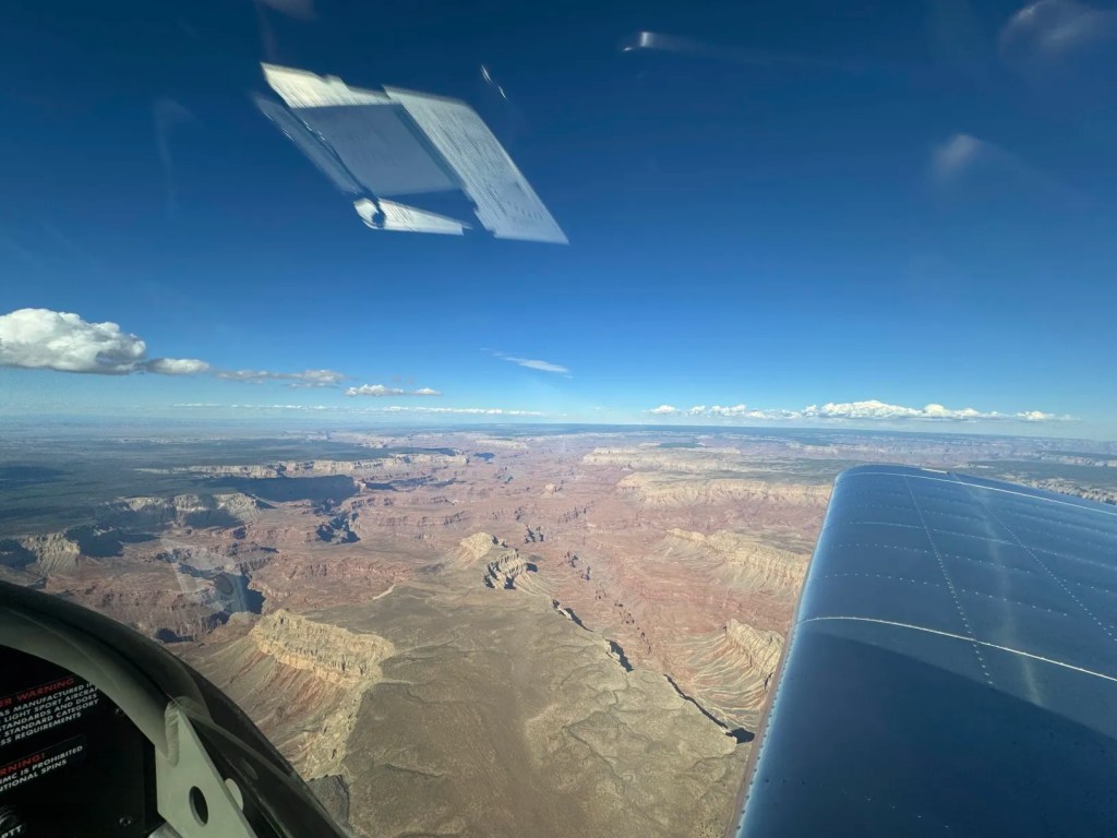
If you ever get a chance, I highly recommend taking a flight over the Grand Canyon, words cannot describe the scale of it.

Leave a comment